The World Map Movie is accessible in two locations in IFs. The first is under the Data Analysis heading on the main IFs screen. The second is under Specialized Display, which is a sub-heading of the Display heading on the Main Menu. The World Map Movie found under the Data Analysis heading deals with historic data, while the World Map Movie found under the Specialized Display heading deals with forecasted data. Selecting the World Map Movie allows the user to display on a map of the world the changes in selected variables over time in all of the countries for which IFs has data. This section describes how to use the various options to tailor the movie to the user’s preferences.
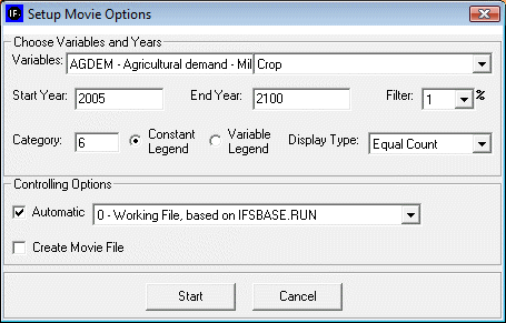
After selecting World Map Movie, the dialog box pictured below appears on the user’s screen.
Choose Variables and Years:
Variables: allows user to select from the entire database of variables in IFs for the Historic World Map Movie. The forecasted World Map Movie includes a more limited database of variables from which to choose.
Start Year: Enter the year from which the movie will begin.
End Year: Enter in the year with which the movie will end.
Filter: User can set the filter from 1% to 100%. This feature sets a minimum value for a portion of the data to be displayed in a given year.
Category: Can be set from 1 to 16. Determines the number of categories to divide the values into.
Constant/Variable Legend: Selecting the constant function will keep the numbers and measurements in the individual categories constant. The numbers and measurements will change over time if the variable legend is selected.
Display Type: When Constant Legend is selected, two options will appear under display type: equal interval and equal count. The equal interval function divides the values equally between categories, with the interval calculated by the equation (highest value-lowest value/number of categories= interval width). The equal count function distributes the number of countries equally between the selected of number of categories. When Variable Legend is selected, a third option becomes available: equal match. If equal match is selected, legend values are assigned to each value uniquely. If there are not enough categories to represent each value, the countries that do not have the selected values are represented as blank.
Controlling Options
Automatic: When deselected, the user scrolls through the years of the movie manually. When selected, the movie will automatically play the start year to the end year.
World/Country: This toggle switch is available only under the Historic World Map Movie. It allows the user to view a movie of changes of the selected variable across the world or, when country is selected, to view a movie of the change in a variable across regions in a country. Three countries are available to the user to select: China, India, and Mexico.
Create Movie file: This toggle switch allows the user to save the movie created. When the playing of the movie is complete, a prompt appears which allows the user to name and save the movie file. The saved movie file is available in Stored Map Movie.
After clicking ‘Start’, the dialogue box will close, and the World Map as pictured below (or similar to it) will appear. This section describes what the user is viewing, and how to manipulate the functions at the bottom of the screen.
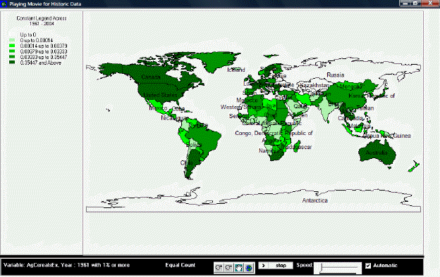
The upper left portion of the screen lists whether the movie is showing a variable or constant legend and across which period of time. Underneath this information is the number of categories and the corresponding color for each category, and the numerical range for each category.
The main portion of the screen is the world map, divided into all countries for which IFs has data. The various shadings of the countries correspond to the various shading of the categories listed in the map legend. By right-clicking on the world map, the user is able to copy the map, zoom in on a particular location of the map, zoom out, or to reset the map to its original point of view.
The bottom section of the screen, from left to right, lists the variable displayed by the map, with the start year shown and the level of the filter. Next is the selected display type. The four buttons to the right of the display type allow the user to zoom in, zoom out, pan, and show the full extent of the world map. The first two buttons allow the user to zoom in on or zoom out from the area under which the cursor is located, while the full extent option resets the view of the world to the original perspective. The pan button allows the user to pan across the world by clicking on different parts of the map, which effectively pans across the world by re-centering the map on the area selected, after having zoomed in or zoomed, without zooming in or out any further. The next set of buttons allows the user to play or pause the movie, and to adjust the speed at which the movie will play. Next is a toggle switch which, when selected, makes the movie play automatically; when the switch is not selected, the user is able to advance the year displayed on the map or to go over previous years.
If the user selected “Create Movie File” during the setup phase, a dialogue box will appear after the movie is finished playing that prompts the user to provide a name and a place to save the movie file. The program will alert the user if the .avi file is successfully created and saved. To review the saved movie file, go to Stored Map Movie.