 International Futures at the Pardee Center
International Futures Help System
Equations: Transportation Infrastructure
The estimated equations for transportation infrastructure in IFs are: 1) the total road density in kilometers per 1000 hectares, INFRAROAD, 2) the percentage of roads that are paved, INFRAROADPAVEDPCNT, and 3) the Rural Access Index, INFRAROADRAI, the percentage of the rural population living within two kilometers of an all-season road. From these we can calculate other transportation indicators.
Total road density
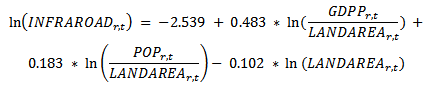
INFRAROAD = road network density in kilometers per 1,000 hectares
GDPP = gross domestic product at purchasing power parity in billion constant 2005 dollars
LANDAREA = land area in 10,000 square kilometers (million hectares)
POP = total population in million persons
- uses extrapolative formulation: extmafuncroad, extmaposnconvtimeroad, extmaposnroad
- additive shift factor: RoadDensShift, downward shift over 300 years, upward shift over 40 years
- multiplier: infraroadm
- value is not allowed to decline in the absence of a target or multiplier or lack of finance for maintenance
- pooled cross-sectional data, OLS regression, R-squared = 0.79
Percentage of total roads that are paved
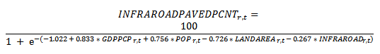
INFRAROADPAVEDPCNT = road network, paved percent in percentage
GDPPCP = gross domestic product per capita at purchasing power parity in thousand constant 2005 dollars
LANDAREA = land area in 10,000 square kilometers (million square hectares)
POP = total population in million persons
INFRAROAD = road network density in kilometers per 1,000 hectares
- uses extrapolative formulation: extmafuncroadpaved, extmaposnconvtimeroadpaved, extmaposnroadpaved
- additive shift factor: INFRARoadPavedPcntShift, downward shift over 500 years, upward shift over 50 years
- multiplier: infraroadpavedpcntm
- value is not allowed to decline in the absence of a target or multiplier or lack of finance for maintenance
- pooled cross-sectional data, OLS regression, R-squared = 0.45
Rural Access Index

INFRAROADRAI = Rural Access Index, percent of rural population living within 2 kilometers of an all-weather road in percentage
GDPPCP = gross domestic product per capita at purchasing power parity in thousand constant 2005 dollars
LANDAREA = land area in 10,000 square kilometers (million square hectares)
POP = total population in million persons
INFRAROAD = road network density in kilometers per 1,000 hectares
- additive shift factor: INFRAROADRAIShift, downward shift over 500 years, upward shift over 50 years
- there is currently no multiplier for INFRAROADRAI
- targeting parameters: infraroadraitrgtval, infraroadraitrgtyr, infraroadraisetar, infraroadraiseyrtar
- value is not allowed to decline unless lack of finance for maintenance
- cross-sectional data, OLS regression, R-squared = 0.51